GEOLOGICAL AND MINING HERITAGE
GEOLOGICAL AND MINING HERITAGE
The Geoparc territory has been inhabited by humans since at least the Middle Palaeolithic, more than 50,000 years ago. We found remains of the presence of our ancestors in different places like the Toll caves (Moià), the Montserrat caves (Collbató), Cardona, Callús, Manresa, Castellfollit del Boix and many other places. Often, this occupation was to take advantage of the natural resources offered by the land, including geological ones. So the caves and coves were excellent shelters, with dolmens made of rock and later the houses and castles, and the exploitation of minerals such as chaton salt and sylvite, and of rocks such as clay, limestone, coal and stoneware (sandstone) has contributed to build our history until today. This continuous presence in the territory has provided this area with a magnificent mining, historical, cultural and traditional heritage that completes the rich and strong personality of the territory.
Now, the history of most of the rocks that form the landscape and that those first humans saw, goes back to the Earth’s early history. At that time, between approximately 41 and 37 million years ago (during the Eocene), a large part of what we now know as Central Catalonia was a sea. The Mediterranean did not exist as such but was a mainland that extended beyond the current Balearic Islands. In the opposite direction, this sea extended through the northeast of the Iberian Peninsula and connected with the Atlantic. From those relays, rivers would flow down, depositing the pebbles, sand and mud they carried in deltas. The most visible parts of those deltas are precisely the mountain of Montserrat and the massif of St. Llorenç del Munt i l’Obac, which would form the part of the estuary. Towards Manresa, passing through Castellgalí, Monistrol de Montserrat, Marganell… or Mura, the Pont de Vilomara i Rocafort, etc. we find the rest of the sediments of those deltas that were already further and further out to sea.

Palaeogeographical evolution of the eastern part of the Ebro Basin during the Palaeogen (A, B and C), compared to the present time (D), carried out from different sources. Author: Oriol Oms, a: Olmos, O., López-Blanco, M., Vilaplana, M.(2016). Introduction to Central Catalonia’s geology. Geological excursions in Central Catalonia. In Olmos, O., Climent, F., González, M. (Eds.). Cartographic and Geological Institute of Catalonia. Technical Monographs, 6: 17 – 65.
36 million years ago, this sea was isolated from the Atlantic due to the effect of the rising of the mountain ranges that surrounded it, such as the Pyrenees, and it became restricted, forming a large salt lake, until it practically evaporated. It left behind a large amount of sediments deposited in different marine environments such as deltas (part of them the current Montserrat and Sant Llorenç del Mult, but also reaching Manresa), reefs (in the areas of Navarcles, Calders, Moià…), sea beds (calcareous and blue-grey marl in Castellgalí, Castellbell i el Vilar, Sant Vicenç de Castellet, etc.), and the coastal areas (with examples in Artés, El Pont de Vilomara i Rocafort, El Pont de Cabrianes…). As a culmination of its final stage, in its evaporation process, the sea left chalk (e.g. Artés) and important granules of salts (potash, halite, carnalite) which have been exploited mainly in Cardona, Súria, Sallent and Balsareny, and which are still quite abundant in the subsoil of the Geoparc. As they disappeared, rivers and lakes took their place and most of the reddish rocks we see in the landscape came into being.
In the last 10 million years, approximately, the rivers that until then drained towards that ancient sea (from Montserrat towards Manresa, to understand it), change direction and are captured by a Mediterranean that already occupied the place it has today, configuring the current new fluvial network. Thus, as a result of these last millions of years, the erosion of all these rocks by rivers such as the Llobregat and the Cardener has shaped the relief (mountains, plains, caves, etc.), in a continuous process that defines the characteristic landscape of the Geoparc.
Want to know more? The best way to learn about this fantastic geology is to visit the Geoparc and step into all this exciting history. Visit the Geoparc!
The following links provide more information about the geology and geological history of the Geoparc:
- Geological Excursions in Central Catalonia,a guidebook published in the XIX Symposium on the Teaching of Geology (2016).
- Brief geological situation of the Central Catalonia UNESCO Global Geopark.
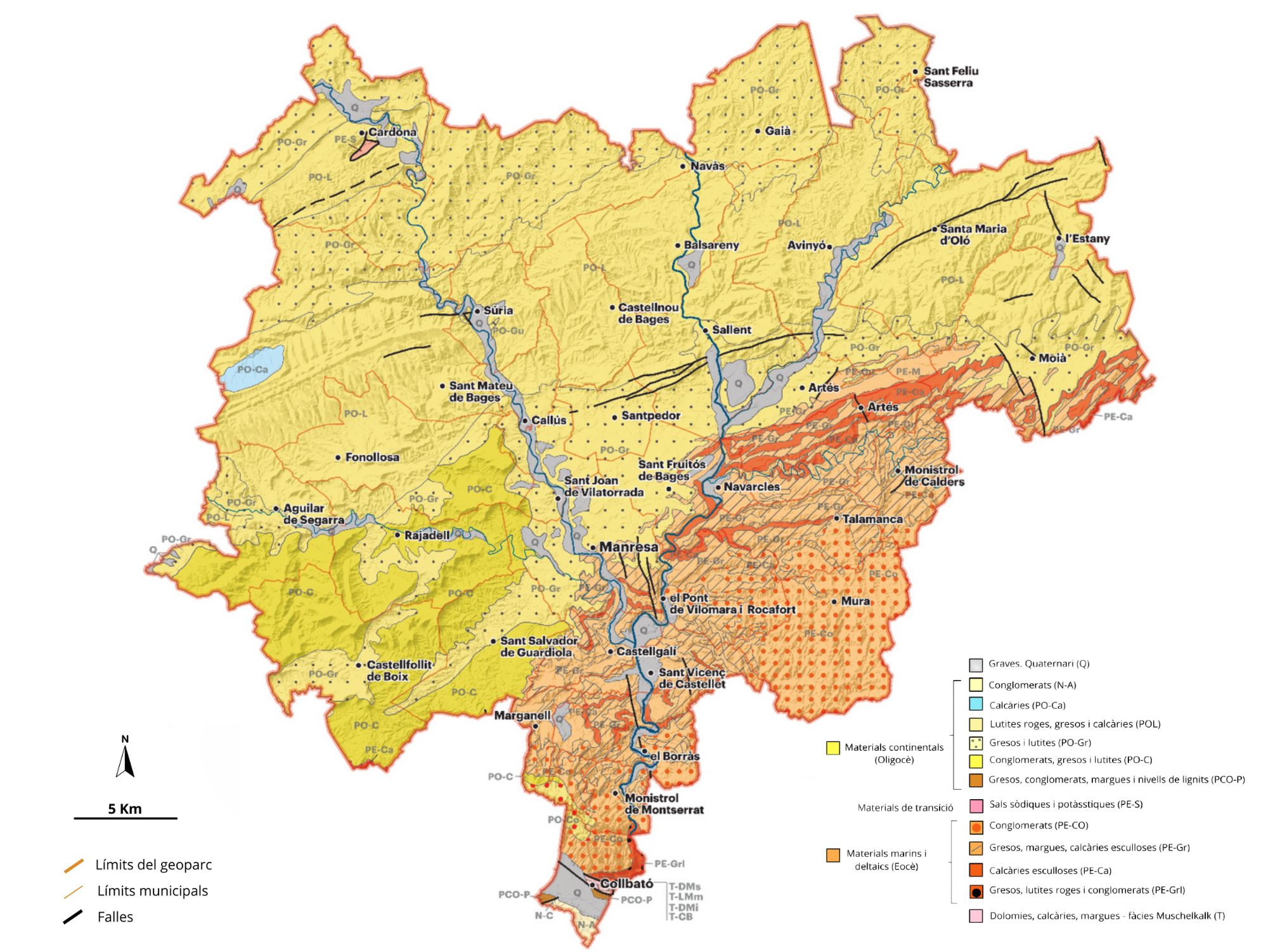
Most of the Geoparc rocks are sedimentary. Metamorphic rocks (pissares, milonites, etc.) can only be found at the southern end of the territory, and they are also the oldest, from the Palaeozoic age. The rest is the result of the sedimentation that took place during the Eocene and Oligocè periods, in a marine context that changed from a continental context in a very short period of time, now 36 million years ago.
There are different types of sedimentary rocks in the Geoparc: detritic (conglomerates and breccias, sandstone and shales), carbonate (limestone) and evaporite (basically chalk, salt and sylvite). Unconsolidated sediments that form part of the material eroded during the most recent geological periods and which essentially correspond to engravings on the river terraces and colluvions on the slopes are also important in the territory.
The Central Catalonia Geopark is a rather unique territory, with remarkable geodiversity, bringing together karst formations in three different types. Limestone, exemplified by the Toll Caves. Evaporites, such as salt and gypsum, characteristic of areas like Cardona, Súria, and Artés. And rocks that are not limestone but can have a carbonate composition—conglomerates—which are prominent in the natural parks of Montserrat and Sant Llorenç del Munt i l’Obac. (More information about the karst in the Geopark in Catalan.)
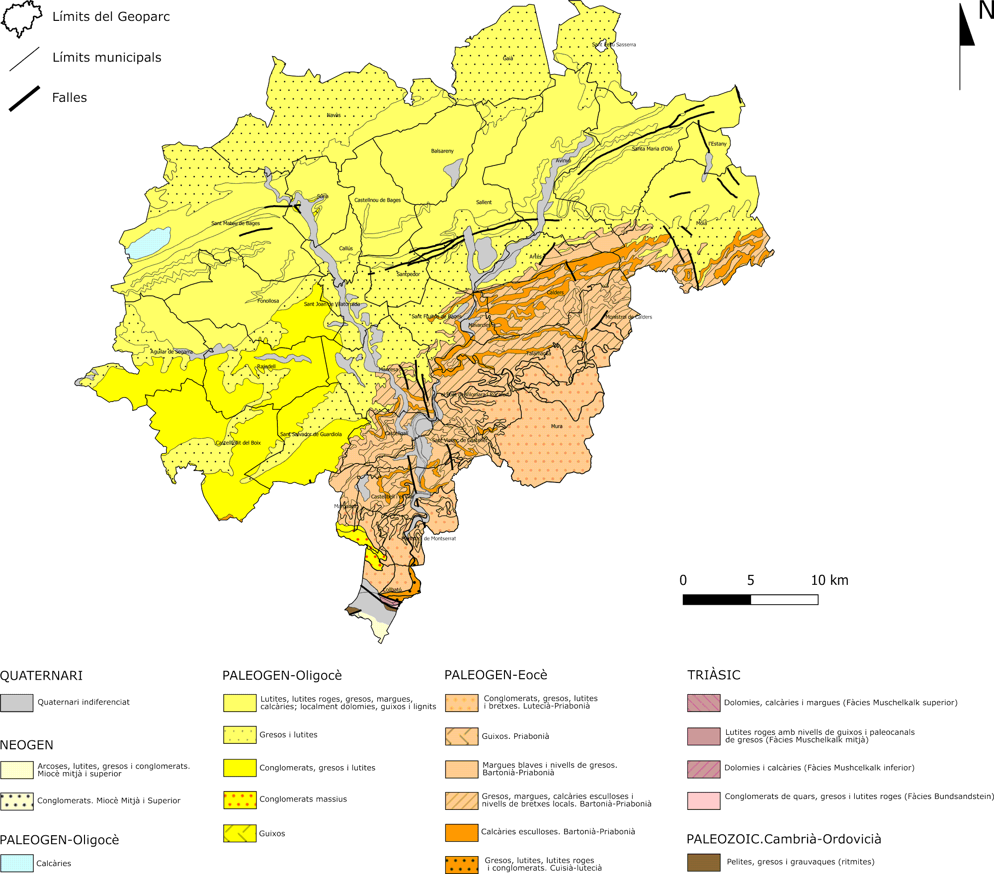
Geologically speaking, the Central Catalonia UNESCO Global Geopark is located in the eastern sector of the so-called Ebro Basin. The main rocks are of sedimentary origin, formed between the Eocene and the Lower Oligocene. The oldest were formed in marine environments (fossiliferous limestone reef, marlstones, etc.), then, as the sea dried up, evaporative sediments of sulphates (chalk) and salts (halite, sylvite, carnalite) were formed. Finally, from about 36 million years ago, by sediments in rivers and lakes. The final evolution of this marine basin (called the Catalonian Potassic Basin) is one of the best examples on a world scale and also contains one of the largest potash mining areas in Europe. In addition, the territory has unique elements recognised internationally such as the Montserrat and Sant Llorenç del Munt Mountains (as examples of delta varieties) or spectacular karstic elements such as the Salt Caves (Collbató), Mura cave and Toll caves (Moià), the latter with important prehistoric and fauna remains from the Quaternary. Other elements of great scientific importance such as the southern manifestations of Pyrenean tectonics, a very representative and characteristic geomorphology and important fossil remains of vertebrates in river terraces and in caves (elephants, rhinoceroses, hippopotamuses, hyenas, among many others), as well as a multitude of outcrops of great didactic and scientific importance.
Salt mining has been developed in the territory since ancient times. The first evidence of the exploitation of halite is from the Neolithic period in the Cardona Salt Mountain, which also appears described in the writings of Plini el Vell (2nd century BC) and quoted by Aulus Geli (2nd century BC) where he transcribes a phrase from Cato that says ‘a great mountain of pure salt that grows as it is extracted’. Along with this mining there has also been the traditional exploitation of clay, limestone, chalk and coal. These natural resources have led to mining activity over many centuries that has left an important heritage.
The continuous human presence, already dated during the Epipalaeolithic, has provided this area with a magnificent historical, cultural and traditional heritage that completes the rich and strong personality of the territory. This unique character of Central Catalonia is also linked to a geology and landscape that have evolved together over millions of years.
A total of 74 catalogued spaces show the great geodiversity of the territory with first order points and examples in many fields of geology. This inventory is not to be understood as a closed and definitive list but is reviewed periodically and this can represent both modifications and additions and deletions. Different geotourism activities and training at all levels are carried out in these spaces.
- Geological heritage: is the «set of geological natural resources of scientific, cultural and/or educational value, whether geological formations and structures, landforms, minerals, rocks, fossils, meteorites, soils and other geological manifestations that allow to know, study and interpret: a) the origin and evolution of the Earth, b) the processes that have shaped it, c) past and present climates and landscapes, and d) the origin and evolution of life» (according to Law 42/2007 on Natural Heritage and Biodiversity). According to this definition, geological heritage can serve as a link between the history of humanity and that of the planet.
- Geodiversity: the term geodiversity is an abbreviation of geological diversity and refers to the diversity of elements that are the result of geological processes and events that have occurred throughout the history of the Earth. Thus, geodiversity, also according to Law 42/2007, is the variety of geological elements (including rocks, minerals, fossils, soils, relief forms, structures, formations and geological units and landscapes) present in a territory and which are the product and record of the evolution of the Earth. Geodiversity is an intrinsic and quantifiable property of the territory.
It is related to geological heritage, but they are different concepts. Geodiversity refers to the variety of elements, while geological heritage refers to their value. In this way, there may be places that are not very diverse, but which have great geological value, but the opposite can also happen. If a place has a lot of geodiversity and this geodiversity has value, then it is considered a heritage to be managed for conservation.
Geological history
The Geoparc territory has been inhabited by humans since at least the Middle Palaeolithic, more than 50,000 years ago. We found remains of the presence of our ancestors in different places like the Toll caves (Moià), the Montserrat caves (Collbató), Cardona, Callús, Manresa, Castellfollit del Boix and many other places. Often, this occupation was to take advantage of the natural resources offered by the land, including geological ones. So the caves and coves were excellent shelters, with dolmens made of rock and later the houses and castles, and the exploitation of minerals such as chaton salt and sylvite, and of rocks such as clay, limestone, coal and stoneware (sandstone) has contributed to build our history until today. This continuous presence in the territory has provided this area with a magnificent mining, historical, cultural and traditional heritage that completes the rich and strong personality of the territory.
Now, the history of most of the rocks that form the landscape and that those first humans saw, goes back to the Earth’s early history. At that time, between approximately 41 and 37 million years ago (during the Eocene), a large part of what we now know as Central Catalonia was a sea. The Mediterranean did not exist as such but was a mainland that extended beyond the current Balearic Islands. In the opposite direction, this sea extended through the northeast of the Iberian Peninsula and connected with the Atlantic. From those relays, rivers would flow down, depositing the pebbles, sand and mud they carried in deltas. The most visible parts of those deltas are precisely the mountain of Montserrat and the massif of St. Llorenç del Munt i l’Obac, which would form the part of the estuary. Towards Manresa, passing through Castellgalí, Monistrol de Montserrat, Marganell… or Mura, the Pont de Vilomara i Rocafort, etc. we find the rest of the sediments of those deltas that were already further and further out to sea.
Palaeogeographical evolution of the eastern part of the Ebro Basin during the Palaeogen (A, B and C), compared to the present time (D), carried out from different sources. Author: Oriol Oms, a: Olmos, O., López-Blanco, M., Vilaplana, M.(2016). Introduction to Central Catalonia’s geology. Geological excursions in Central Catalonia. In Olmos, O., Climent, F., González, M. (Eds.). Cartographic and Geological Institute of Catalonia. Technical Monographs, 6: 17 – 65.
36 million years ago, this sea was isolated from the Atlantic due to the effect of the rising of the mountain ranges that surrounded it, such as the Pyrenees, and it became restricted, forming a large salt lake, until it practically evaporated. It left behind a large amount of sediments deposited in different marine environments such as deltas (part of them the current Montserrat and Sant Llorenç del Munt, but also reaching Manresa), reefs (in the areas of Navarcles, Calders, Moià…), the sea beds (calcareous and blue-grey marl in Castellgalí, Castellbell i el Vilar, Sant Vicenç de Castellet, etc.), and the coastal areas (with examples in Artés, El Pont de Vilomara i Rocafort, El Pont de Cabrianes…). As a culmination of its final stage, in its evaporation process, the sea left chalk (e.g. Artés) and important granules of salts (potash, halite, carnalite) which have been exploited mainly in Cardona, Súria, Sallent and Balsareny, and which are still quite abundant in the subsoil of the Geoparc. As they disappeared, rivers and lakes took their place and most of the reddish rocks we see in the landscape came into being.
In the last 10 million years, approximately, the rivers that until then drained towards that ancient sea (from Montserrat towards Manresa, to understand it), change direction and are captured by a Mediterranean that already occupied the place it has today, configuring the current new fluvial network. Thus, as a result of these last millions of years, the erosion of all these rocks by rivers such as the Llobregat and the Cardener has shaped the relief (mountains, plains, caves, etc.), in a continuous process that defines the characteristic landscape of the Geoparc.
Want to know more? The best way to learn about this fantastic geology is to visit the Geoparc and step into all this exciting history. Visit the Geoparc!
The following links provide more information about the geology and geological history of the Geoparc:
- Geological Excursions in Central Catalonia,a guidebook published in the XIX Symposium on the Teaching of Geology (2016).
- Brief geological situation of the Central Catalonia UNESCO Global Geopark.
Geopark’s rocks
Most of the Geoparc rocks are sedimentary. Metamorphic rocks (pissares, milonites, etc.) can only be found at the southern end of the territory, and they are also the oldest, from the Palaeozoic age. The rest is the result of the sedimentation that took place during the Eocene and Oligocè periods, in a marine context that changed from a continental context in a very short period of time, now 36 million years ago.
There are different types of sedimentary rocks in the Geoparc: detritic (conglomerates and breccias, sandstone and shales), carbonate (limestone) and evaporite (basically chalk, salt and sylvite). Unconsolidated sediments that form part of the material eroded during the most recent geological periods and which essentially correspond to engravings on the river terraces and colluvions on the slopes are also important in the territory.
The Central Catalonia Geopark is a rather unique territory, with remarkable geodiversity, bringing together karst formations in three different types. Limestone, exemplified by the Toll Caves. Evaporites, such as salt and gypsum, characteristic of areas like Cardona, Súria, and Artés. And rocks that are not limestone but can have a carbonate composition—conglomerates—which are prominent in the natural parks of Montserrat and Sant Llorenç del Munt i l’Obac. (More information about the karst in the Geopark in Catalan.)


Geological and Mining Heritage
Geologically speaking, the Central Catalonia UNESCO Global Geopark is located in the eastern sector of the so-called Ebro Basin. The main rocks are of sedimentary origin, formed between the Eocene and the Lower Oligocene. The oldest were formed in marine environments (fossiliferous limestone reef, marlstones, etc.), then, as the sea dried up, evaporative sediments of sulphates (chalk) and salts (halite, sylvite, carnalite) were formed. Finally, from about 36 million years ago, by sediments in rivers and lakes. The final evolution of this marine basin (called the Catalonian Potassic Basin) is one of the best examples on a world scale and also contains one of the largest potash mining areas in Europe. In addition, the territory has unique elements recognised internationally such as the Montserrat and Sant Llorenç del Munt Mountains (as examples of delta varieties) or spectacular karstic elements such as the Salt Caves (Collbató), Mura cave and Toll caves (Moià), the latter with important prehistoric and fauna remains from the Quaternary. Other elements of great scientific importance such as the southern manifestations of Pyrenean tectonics, a very representative and characteristic geomorphology and important fossil remains of vertebrates in river terraces and in caves (elephants, rhinoceroses, hippopotamuses, hyenas, among many others), as well as a multitude of outcrops of great didactic and scientific importance.
Salt mining has been developed in the territory since ancient times. The first evidence of the exploitation of halite is from the Neolithic period in the Cardona Salt Mountain, which also appears described in the writings of Plini el Vell (2nd century BC) and quoted by Aulus Geli (2nd century BC) where he transcribes a phrase from Cato that says ‘a great mountain of pure salt that grows as it is extracted’. Along with this mining there has also been the traditional exploitation of clay, limestone, chalk and coal. These natural resources have led to mining activity over many centuries that has left an important heritage.
The continuous human presence, already dated during the Epipalaeolithic, has provided this area with a magnificent historical, cultural and traditional heritage that completes the rich and strong personality of the territory. This unique character of Central Catalonia is also linked to a geology and landscape that have evolved together over millions of years.
A total of 74 catalogued spaces show the great geodiversity of the territory with first order points and examples in many fields of geology. This inventory is not to be understood as a closed and definitive list but is reviewed periodically and this can represent both modifications and additions and deletions. Different geotourism activities and training at all levels are carried out in these spaces.
When visiting the Geopark, respect the geological heritage, do not damage the outcrops and remember that it is forbidden to collect fossils.
Cover photo: Vilafresca i Ca l’Estruch de Navàs coasts | Òscar Rodbag